Geography
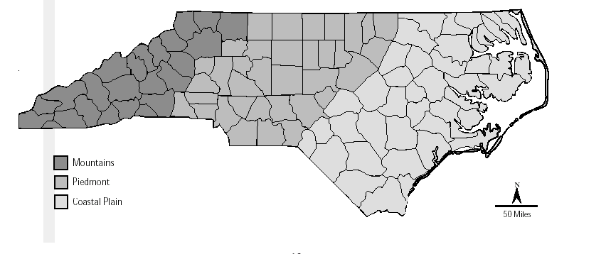
From Manteo in the east to Murphy in the west, North Carolina is 560 miles wide, making it the widest state east of the Mississippi. Bordered by the Atlantic Ocean on the east, Tennessee on the west, Virginia to the north, and South Carolina and Georgia to the south, North Carolina is divided into three distinct geographic areas: the Coastal Plain in the east, the Piedmont in the center, and Mountains in the west.

The Coastal Plain
The low, flat land of North Carolina's eastern region stretches from the sandy farmland of the Inner Coastal Plain to the state's Outer Banks, a string of barrier islands separated from the mainland by sounds or inlets. The Outer Banks has three capes -- Cape Hatteras, Cape Lookout, and Cape Fear.
The Piedmont
Piedmont is a French word meaning "foot of the mountain," and North Carolina's Piedmont region is sometimes referred to as "the foothills." The rolling hills of this region range in elevation from just 300 feet in the east to 1,500 feet near the mountains. The Piedmont is sometimes referred to as a plateau because it is high and mostly flat.
The Mountains
Western North Carolina's majestic landscape features the Blue Ridge Mountains and the Great Smoky Mountains, which help make up the Appalachian Mountains, possibly the oldest mountain range in the United States. The region is also home to Mount Mitchell. Rising 6,684 feet above sea level, Mount Mitchell is the tallest peak east of the Mississippi River. The Eastern Continental Divide runs along the top of the Blue Ridge Mountains, separating the rivers flowing east from those flowing west. Rivers that fall on the eastern side of the divide flow toward the Atlantic Ocean while those on the western side of the divide flow toward the Tennessee and Ohio rivers and into the Gulf of Mexico.
Climate
While North Carolina is located in a warm temperate zone, its diverse regions can experience a great variety of weather conditions. While locations in the mountains may see average temperatures of 30 degrees Fahrenheit in January and 65 degrees Fahrenheit in August, locations in the coastal plains can often experience January averages in the mid 40's and August averages in the 90's. The state averages 44 inches of rainfall each year, and 5 inches of snow.
